Whose road is it?
Within town boundaries where kerb exists, VicRoads is responsible for maintenance from ‘back of kerb to back of kerb’ and where no kerb is present, ‘drain to drain’.
Outside of town boundaries (80km signs), VicRoads is responsible for maintenance from ‘fence to fence’.
Visit VicRoads to access the interactive map of declared roads or see the map below:
You can report an issue with a VicRoads road online or contacting VicRoads on 13 11 70.
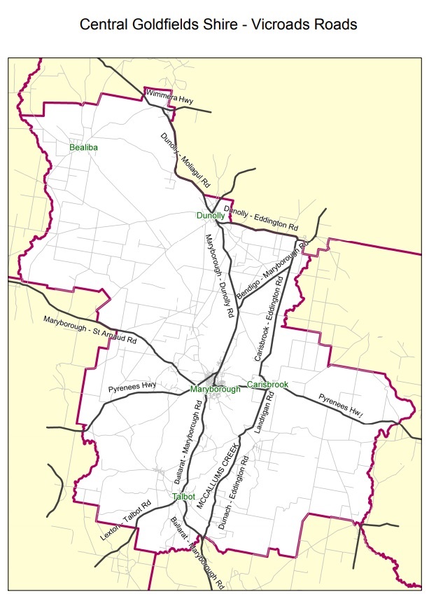
Vicroads Roads within Central Goldfields Shire
Within the Central Goldfields Shire Council there are several VicRoads arterial roads, these include:
- Pyrenees Hwy
- Ballarat Maryborough Rd
- Bendigo Maryborough Rd
- Maryborough Dunolly Rd
- Maryborough St Arnaud Rd
- Dunolly Eddington Rd
- Dunolly Moliagul Rd
- Dunolly Bridgewater Rd
- Carisbrook Eddington Rd
- Landrigan Rd (Craigie Cross Roads to Carisbrook)
- Bucknall St Carisbrook
- Lexton Talbot Rd
- Mccallums Creek Rd (Landrigan Rd To Ballarat Maryborough Rd)
Map of VicRoads roads in Central Goldfields Shire. (PDF, 541KB)
Vicroads Roads within Maryborough town boundaries
Within the Maryborough township boundaries the following roads are VicRoads roads:
- Gladstone St
- Park Rd
- Elgin Rd
- Derby Rd
- Phelan Rd
- High Street (Derby Rd to Inkerman St)
- Inkerman St (High St to Napier St)
- Napier St (Inkerman St to Tuaggra St)
- Tuaggra St
- Sutton Rd
For more information you can access the Central Goldfields Shire Municipal Public Road Register(PDF, 2MB) .